San Diego Hiking
Trails Covered
Turtle Head Mountain Trail ~4.6 miles
Stanley Peak via Creek Crossing Trail ~5.8 miles
Cougar Ridge to Bobcat Trail ~3 miles
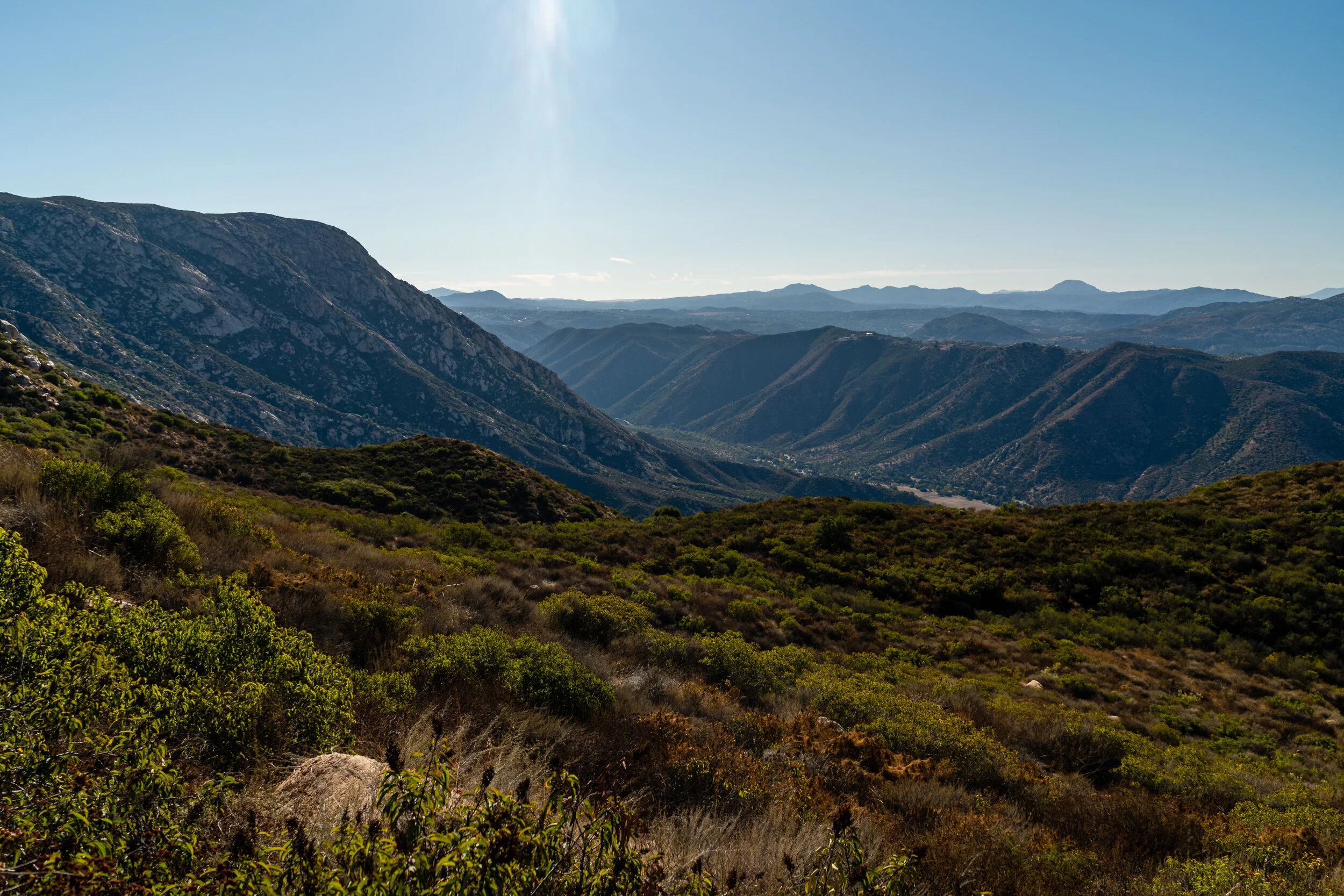
El Cajon Mountain Trail ~14 miles
Iron Mountain Trail ~5.2 miles
Ellie Lane Trail to Iron Mountain Trail ~8.5 miles
Woodson Mountain and Potato Chip Rock via Hwy 67 ~4.1 miles
Potato Chip Rock via Mt. Woodson Trail ~7.5 miles
Monserate Mountain Trail Loop ~4 miles
Stanley Peak via Creek Crossing Trail ~5.8 miles
Mother Miguel Mountain via Rock House Trail ~4 miles
Tecolote Canyon Trail ~6.5 miles
Piedras Pintadas Interpretive Trail ~4 miles
Calavera Lake Loop ~2 miles
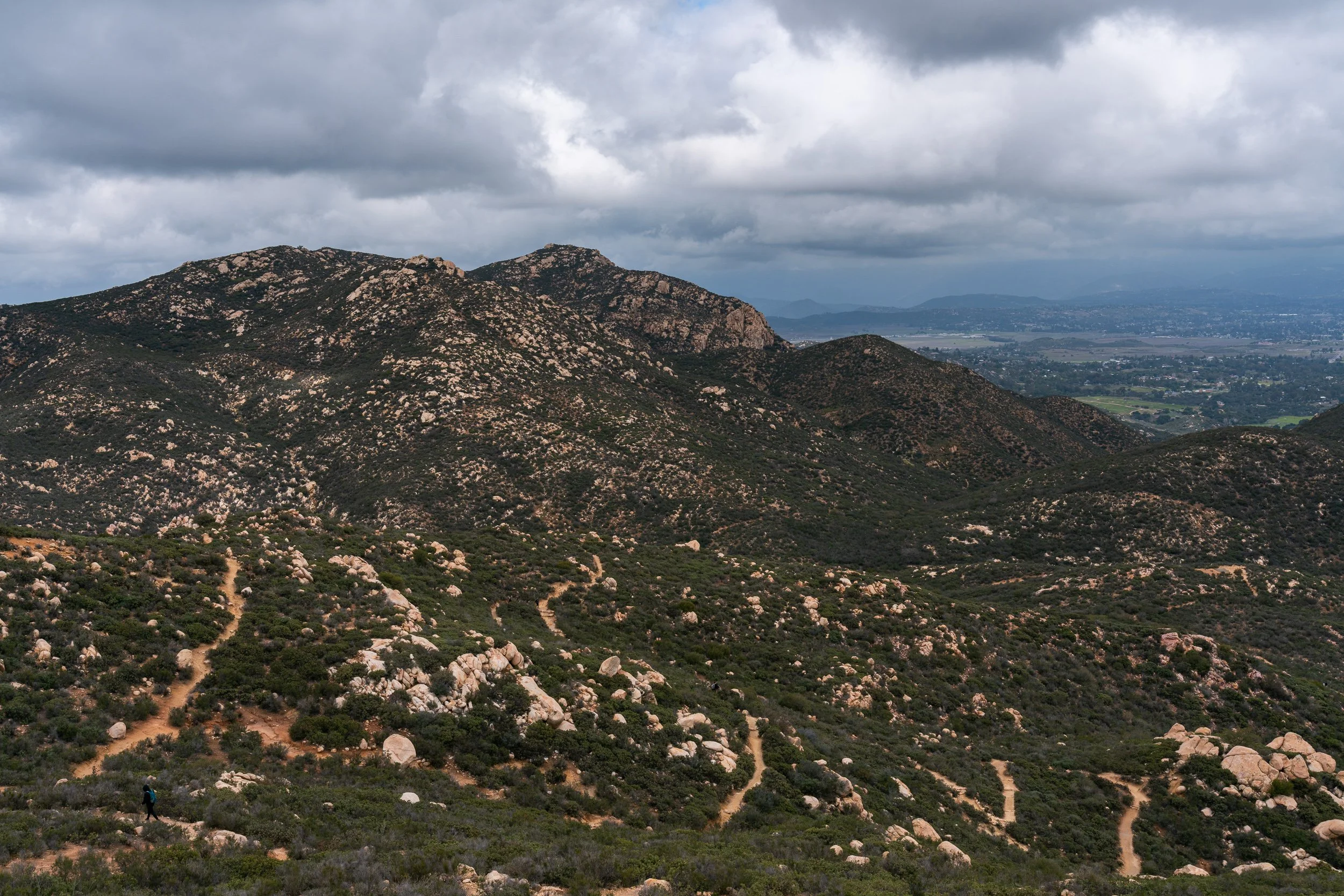
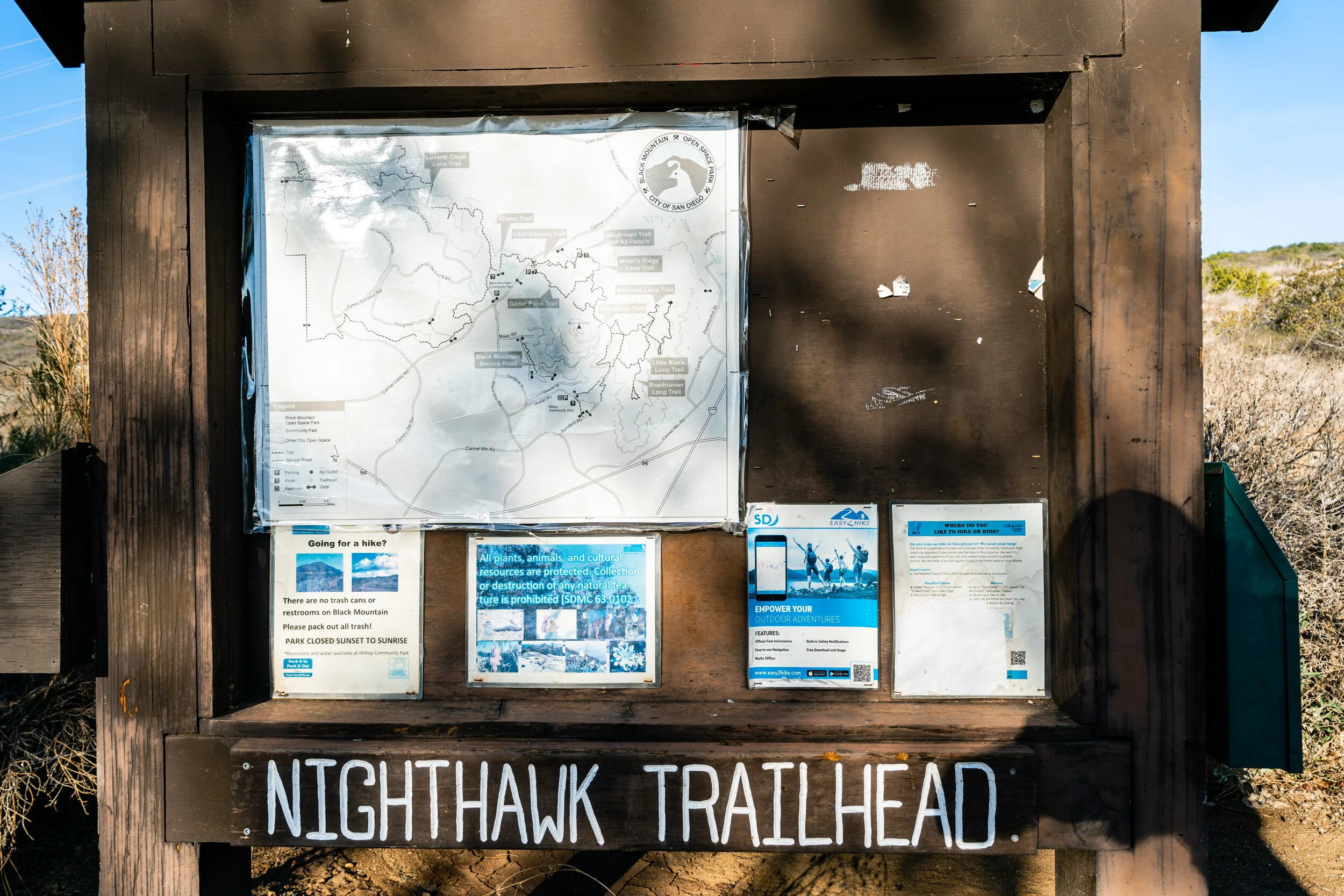
Black Mountain via Miner's Ridge Loop ~4.3 miles
Nighthawk Trail to Black Mountain Summit ~3.9 miles
Lake Hodges Coast to Crest Trail ~6.5 miles
Lakes Hodges Overlook Trail ~7.3 miles
Elfin Forest Loop ~4.7 miles
Bernardo Mountain Summit via La Calma ~3.6 miles
Penasquitos Falls Loop via Carmel Valley ~3 miles
Blue Sky Canyon Trail ~5 miles
Wildflower Trail to Spooks Canyon ~3 miles
Los Peñasquitos Canyon Preserve (Sea to Sea Trail) ~5 miles
Martha's Grove Trail Loop ~3.5 miles
Lake Jennings Trail ~5 miles
San Dieguito Park Trail ~3 miles
Twin Peaks Trail ~2 miles
South Lake Park Trail ~1.3 miles
Double Peak Trail from Discovery Lake ~4 miles
Turtle Head Mountain Trail
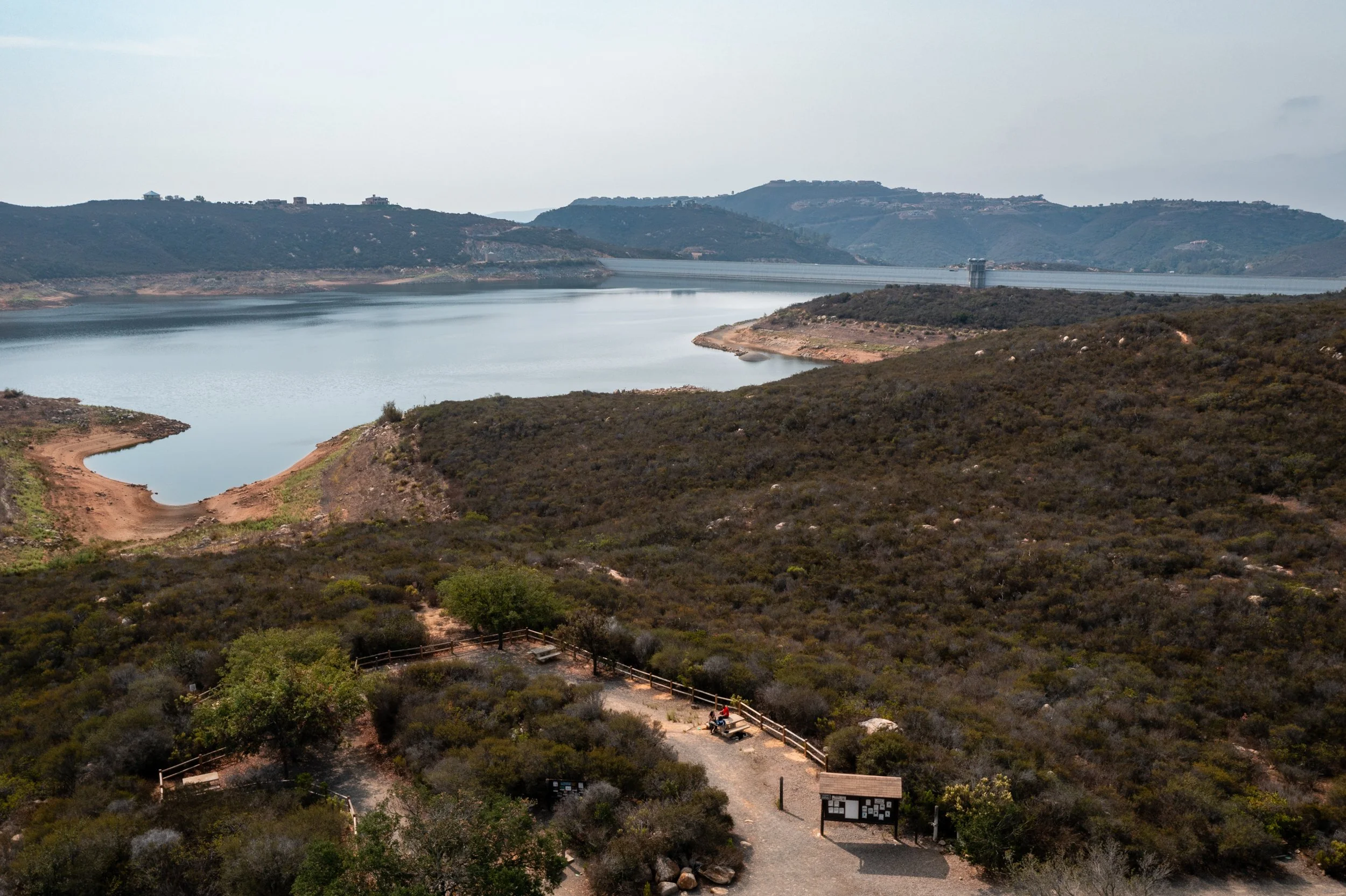
Turtle Head Mountain Trail is a 4.6-mile hike located near Escondido. It features beautiful views of Lake Hodges and ends at Fletcher Point. In my opinion, this trail is one of the more beautiful hikes in the city of San Diego, but then again, I am a sucker for those lake views.
~4.6 miles | ~734 feet elevation gain | Out and Back trail
Recommendation: Be mindful of the surrounding neighborhood.

Stanley Peak via Creek Crossing Trail
Stanley Peak is located in Daley Ranch, Escondido. This specific video focuses on Stanley Peak via Creek Crossing Trail - with some minor variations. Stanley Peak is beautiful and provides magnificent views at the top. Watch the video to learn how I ended up getting a ticket here and which trails might be a better option for you as you make your way to the top - especially for sunrise or sunset!
~5.8 miles | ~918 feet elevation gain | Out and Back trail
Recommendation: Be on the lookout for snakes in this area.

Cougar Ridge to Bobcat Trail
Daley Ranch located in Escondido is huge and a great place to find a lot of trails. This week's video focuses on Cougar Ridge to Bobcat Trail - a 3-mile loop that starts in the northwest part of Daley Ranch. This trail is mostly shaded, which makes it a perfect outdoor adventure during these hot summer days!
~3 miles | ~500 feet elevation gain | Loop trail
Recommendation: Be on the lookout for snakes in this area.

El Cajon Mountain Trail
El Cajon Mountain Trail is the hardest hike in San Diego.
This hike is described as uphill both ways and although AllTrails says it is 11.3 miles, my watch has clocked it at 14 miles during 2 separate trips. Make sure you check out this video if you are planning on heading out to take on this challenge!
~14 miles | ~3,600 feet elevation gain | Out and Back trail
Recommendation: Avoid this hike in the summertime. Make sure you take more water than you think you will need.
Iron Mountain Trail
One of San Diego's most popular hikes, the Iron Mountain Trail leads to the second highest peak in Poway. Iron Mountain is a San Diego favorite! watch the video and find out why, along with how to get there and other trail details.
~5.2 miles | ~1,100 feet elevation gain | Out and Back trail
Recommendation: Get there early or you will have a hard time finding a parking spot.

Ellie Lane Trail to Iron Mountain Trail
Ellie Lane is the best trail to use to head up to Iron Mountain - hands down. As I mention in the video, Ellie Lane adds about 2.5 miles and ~1,000 feet of elevation to your hike up to Iron mountain. This trail is an amazing extension trail if you are looking to train or want some overall solitude on your hike up to Iron mountain.
~8.5 miles | ~2,000 feet elevation gain | Loop trail
Recommendation: Get there early or you will have a hard time finding a parking spot.
Woodson Mountain and Potato Chip Rock via Hwy 67
This trail is the less-trafficked approach from the east side to the top of Woodson Mountain or better known as the famous potato chip rock. This trail is steep, as you climb over 1200 feet in 2 miles. Most of this trail is paved.
~4.1 miles | ~1,200 feet elevation gain | Out and Back trail
Recommendation: This area is well preserved - practice your leave no trace principles.

Potato Chip Rock Via Mt. Woodson Trail
This trail begins at Lake Poway and is the '“long way up” to Potato Chip. This trail is a great workout and I recommend you visit it during the non-summer months as it has little to no shade.
~7.3 miles | ~2,100 feet elevation gain | Out and Back trail
Recommendation: Fees and traffic are on the weekend - try to visit during the weekday instead. Kid and Dog friendly.

Monserate Mountain Trail Loop
Monserate Mountain is an urban hike located in Fallbrook, Northern County San Diego. Just off the I-15, Monserate Mountain is what I call a 'workout hike'. Watch the video to find out what the best way to loop this trail is and if you should consider checking it out!
~4.1 miles | ~1,400 feet elevation gain | Loop trail
Recommendation: This area is well preserved - practice your leave no trace principles.

Mother Miguel Mountain via Rock House Trail
Mother Miguel Mountain is in the shadow of the much more impressive San Miguel Mountain (aka Mt Miguel). However, since San Miguel Mountain is not open to the public, Mother Miguel is one of the few easily accessible hikes with notable elevation gain in Chula Vista.
~4 miles | ~550 feet elevation gain | Out and Back trail
Recommendation: Don’t expect to find solitude on this hike, but you will be rewarded with a great workout and fantastic views of the South Bay.

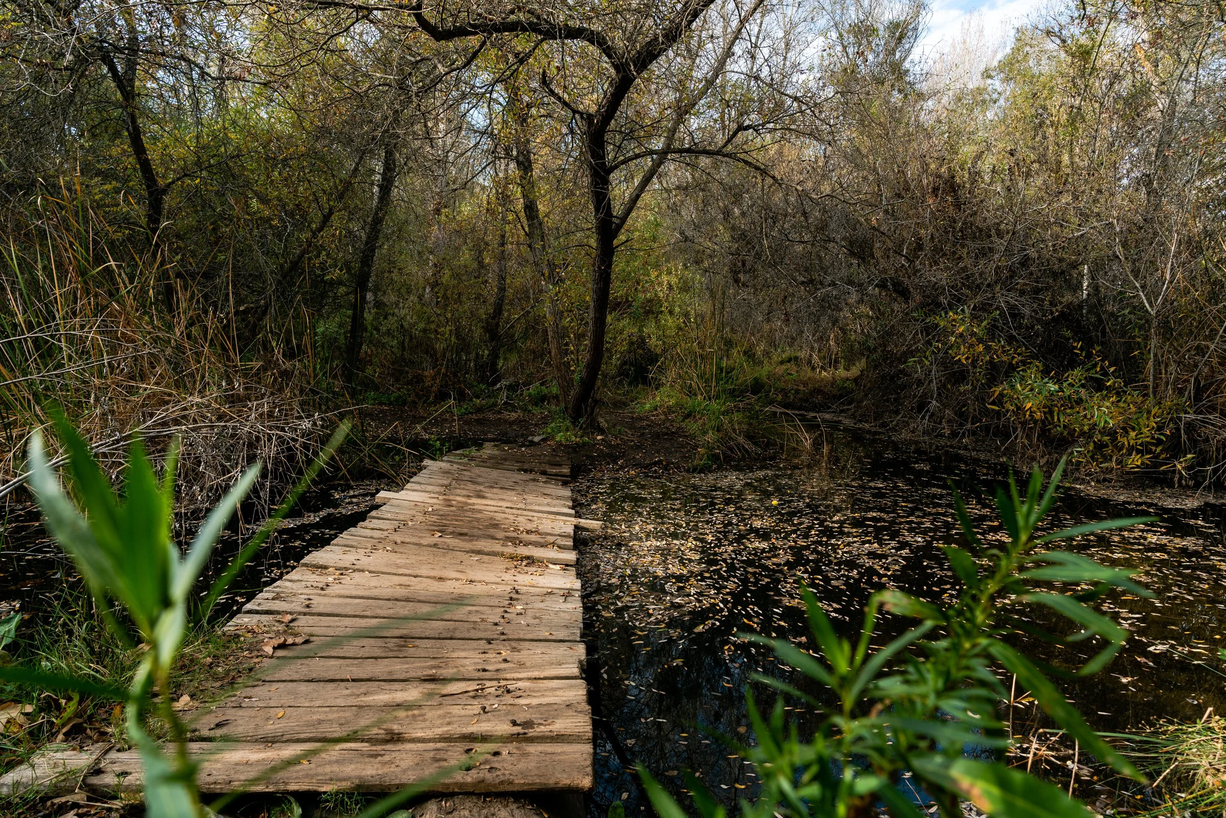
Tecolote Canyon Trail
Tecolote Canyon trail is a scenic 6.4-mile out-and-back trail in San Diego, California. This trail offers a mix of flat terrain and gentle inclines, making it perfect for hikers of all levels. After rainfall, expect some creek crossings towards Genesee. While the main trail is straightforward, there are numerous side routes to explore - make sure you know what trails diverge so you don't get lost.
~6.5 miles | ~400 feet elevation gain | Out and Back trail
Recommendation: Use Google Maps. It is easy to wander the wrong trail and make this hike even longer.

Piedras Pintadas Interpretive Trail
Piedras Pintadas Interpretive Trail is one of my new favorite urban trails in San Diego. Start your journey from the parking area located on West Bernardo Drive to access the Interpretive Trail. As you proceed, you'll encounter informative signs detailing the rich history of the indigenous peoples in the region. Crossing over Green Valley Creek, you'll trek through a terrain adorned with sizable boulders, small trees, and shrubs. The loop segment offers captivating vistas of the lake.
~3.7 miles | ~300 feet elevation gain | Loop trail
Recommendation: This is an unexpected waterfall hike following heavy rain.

Calavera Lake Loop
The Calavera Loop trail is a scenic ~2-mile loop in Carlsbad, California. It's a popular spot for hiking, running, and mountain bikers, and you can expect to encounter other outdoor enthusiasts. This trail is open year-round and offers beauty in every season. Leashed dogs are welcome! What makes this trail special? It was once a volcano and is now dormant. What's truly remarkable is the diverse plants and wildlife in the area.
~2 miles | ~150 feet elevation gain | Loop trail
Recommendation: There are a lot of different trails to explore in this area

Black Mountain via Miner’s Ridge Trail
Black Mountain is a great place to hike and Mountain Bike if you are in a community nearby. Specifically, Miner's Ridge Loop is a crowd favorite on this mountain because it provides shade in some areas and the incline is steady. The trail has a lot of wildflowers and the summit provides great views of the green landscape and communities nearby and on a clear day, the ocean!
~4.3 miles | ~800 feet elevation gain | Loop trail
Recommendation: Download a map - make sure you don’t take a wrong turn.

Nighthawk Trail to Black Mountain Summit
Black Mountain provides a great opportunity for folks in the surrounding neighborhoods to hike, bike, and relax a bit. This urban hike provides great visibility to the area around and on a clear day, downtown La Jolla can be seen in the distance.
~3.9 miles | ~850 feet elevation gain | Out and Back trail
Recommendation: A bit rocky - a good hike to bring your poles
Lake Hodges Coast to Crest
This is an incredibly easy hike or nature walk. The reason I would classify this as more of a nature walk is that there is almost no incline to this trail. This hike is perfect for those who need to relax on an afternoon - enjoy the lake views, the wildflowers, and stay local in San Diego. Very easy trail and perfect to enjoy with the whole family.
~6.5 miles | ~150 feet elevation gain | Out and Back trail
Recommendation: very flat trail, but it is long - bring plenty of water and comfortable shoes.

Lake Hodges Overlook Trail
This hike has magnificent views and the switchbacks make the trail moderate at its hardest parts. After tackling the switchbacks, you will see views of the Olivenhain Reservoir. Following the reservoir, you'll reach Lake Hodges Overlook - where you have panoramic views of the lake and mountain peaks nearby. Keep an eye out for the pacific ocean on a clear day!
~7.3 miles | ~1,400 feet elevation gain | Loop trail
Recommendation: This hike is not for sunrise or sunset - mainly because they are strict about closing the parking for Elfin Forest (watch the video for additional details).
Elfin Forest Loop
The Elfin Forest is a hidden gem located in Escondido. “One of San Diego County’s most precious natural resources, the Reserve offers approximately 11 miles of hiking, mountain biking, and equestrian trails, as well as picnic areas and scenic mountain viewing points.”
~4.7 miles | ~800 feet elevation gain | Loop trail
Recommendation: This location is great to bring the whole family - go counterclockwise.
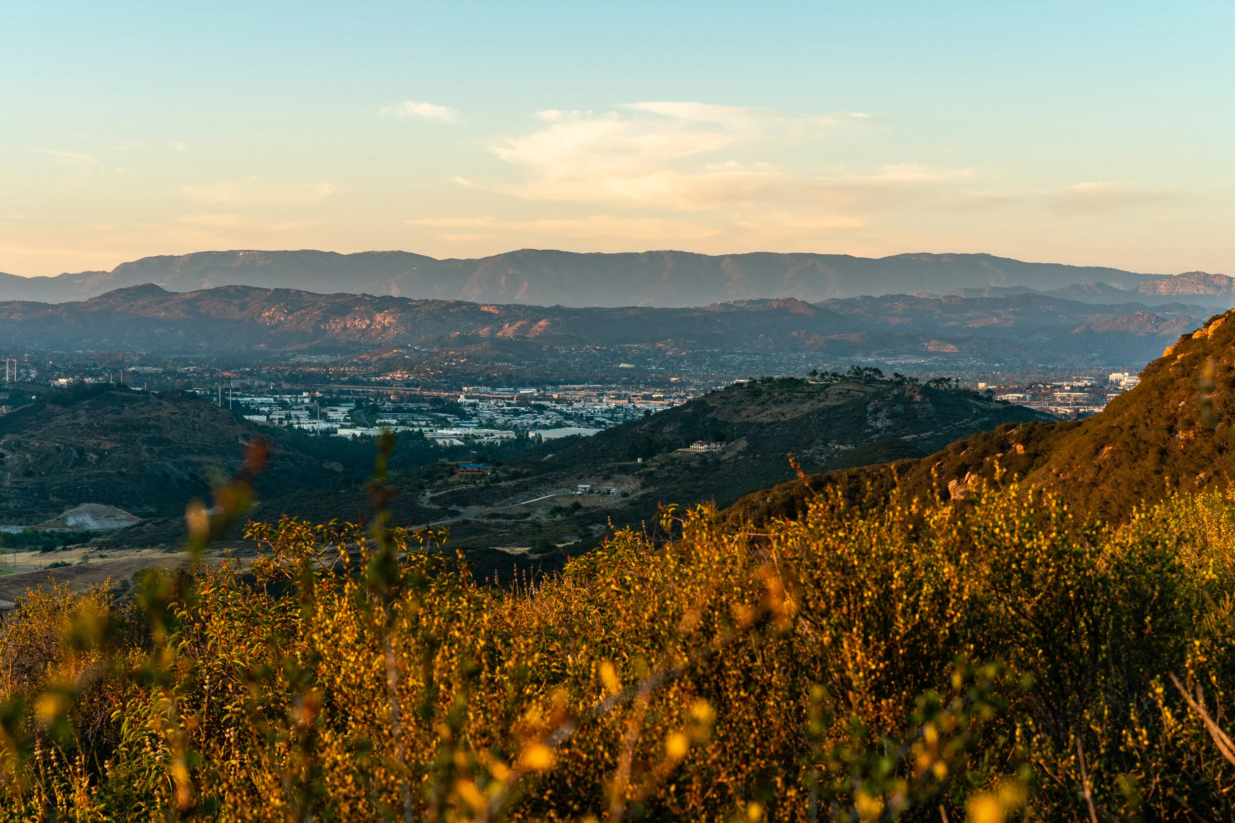
Bernardo Mountain Summit via La Calma
Bernardo Summit is a beautiful short hike located in Escondido, San Diego. This is a great urban hike to catch the sunrise or sunset. Seeing Lake Hodges from up here for sunset was beautiful and it is a quick family hike I definitely recommend.
~3.8 miles | ~800 feet elevation gain | Out and Back trail
Recommendation: This hike is perfect for sunrise or sunset. Please be respectful of the neighborhood when you park.

Penasquitos Falls Loop via Carmel Valley
Penasquitos Falls Loop is an incredibly popular hike in San Diego because it is one of the few places where a "waterfall" can be seen. This is rare to have within the city of San Diego and therefore, attracts a lot of foot traffic. I was pleasantly surprised with how beautiful the trail to the falls was (Sycamore Crossing), but I probably won't be back here for a while. Watch the video to find out why along with some other important tips!
~3 miles | ~450 feet elevation gain | Loop trail
Recommendation: Kids and pets may not be able to cross the falls - be careful
Blue Sky Canyon Trail
Blue Sky Canyon trail is an excellent summer afternoon trail or a perfect addition to hiking up to potato chip. This trail begins in the Blue Sky ecological reserve and takes you around Poway lake (loop). Make sure you watch the video to learn more about the trail and certain places dogs are not allowed.
~5 miles | ~650 feet elevation gain | Loop trail
Recommendation: Perfect extension trail for Mt Woodson (potato chip)
Wildflower Trail to Spooks Canyon Loop
Wildflower Trail to Spooks Canyon is a fantastic and quick ~3-mile urban hike in Rancho Santa Fe. If you go during the right time of year, you will see Escondido Creek flowing and wildflowers blooming.
~3 miles | ~350 feet elevation gain | Loop trail
Recommendation: Make sure you don’t get lost and spend some time exploring Spooks Canyon
Los Peñasquitos Canyon Preserve (Sea to Sea Trail)
San Diego Sea to Sea Trail via Camino Ruiz Park. Los Peñasquitos Canyon Preserve boasts stunning natural beauty and a hidden waterfall. Located in San Diego County, this pristine preserve is a haven for nature enthusiasts.
~5 miles | ~350 feet elevation gain | Out and Back trail
Recommendation: Rocks are slippery. Be careful near the falls

Martha Grove Trail Loop
Martha's Grove Loop Trail in Sycamore Canyon provides a serene escape into nature. This family-friendly hike winds through lush sycamore groves, offering peaceful moments amidst chirping birds and rustling leaves. You might even spot local wildlife and enjoy breathtaking views. Whether an experienced hiker or seeking a tranquil outdoor stroll, it's a perfect place to reconnect with nature and recharge.
~3.5 miles | ~400 feet elevation gain | Loop trail
Recommendation: This trail is one way only

Lake Jennings Trail Loop
The Lake Jennings trail, spanning a picturesque 5 miles, is accessible during regular lake operating hours on Fridays, Saturdays, and Sundays. Additionally, exploring the perimeter and navigating through the Campground is an option every day for registered campers or visitors who acquire a day-use permit. However, it's essential to watch the video to understand one crucial detail that dissuades me from recommending this trail.
~5 miles | ~300 feet elevation gain | Loop trail
Recommendation: Full perimeter trail is only open Fri-Sun

San Diegito Park Trail
San Dieguito Park Trail, nestled near Solana Beach, is an ideal spot for a family adventure. However, navigating it using AllTrails can be tricky, so I recommend downloading a map and checking out the video guide. It'll point out key stops, the main entrances, entrance fees, etc. As it's a popular area for hiking, mountain biking, and strolling, expect to encounter fellow outdoor enthusiasts. Open year-round, the trail boasts timeless beauty, making it enjoyable for any visit. And yes, furry friends are welcome, just remember to keep them on a leash!
~3 miles | ~400 feet elevation gain | Loop trail
Recommendation: Trail can be challenging to follow. Watch the video to ensure you don’t miss the recommended stops within the park

Twin Peaks Trail
Twin Peaks Trail in Poway, San Diego, is a popular hiking trail that offers stunning panoramic views of the surrounding area. One of the reasons this trail is popular is the incredible scenic views at the top. At the summit of Twin Peaks, hikers are rewarded with a 360-degree panoramic view of the surrounding landscape, including the city of Poway, Lake Poway, and on clear days, even the Pacific Ocean and downtown San Diego.
~2 miles | ~700 feet elevation gain | Loop trail
Recommendation: Watch the video to learn why I do not recommend you loop this.

South Lake Park Trail
South Lake Park Trail is a ~1.3 mile loop encircling South Lake, a transformed reservoir located in San Marcos. This 10-acre park, which opened to the public in April 2023, offers scenic views and an accessible trail suitable for casual hikes and leisurely walks. The trail features gentle inclines and a well-maintained dirt path, providing a relaxing experience with constant views of the lake. Fishing is allowed, and visitors may encounter a variety of wildlife, including bass, bluegill, Western pond turtles, and local mammals like deer and coyotes.
~1.3 miles | ~100 feet elevation gain | Loop trail
Recommendation: Limited parking. Get there early

Double Peak Trail from Discovery Lake
Double Peak Trail from Discovery Lake in San Marcos, California, is a well-known hiking route that offers a rewarding experience for outdoor enthusiasts. Starting at Discovery Lake, which provides parking facilities and amenities like picnic tables and restrooms, the trail covers about 4.2 miles round trip. The hike is moderate to challenging, featuring a steady ascent to the summit of Double Peak, the highest point in North County San Diego.
~4 miles | ~1,000 feet elevation gain | Loop trail
Recommendation: Urban hike. Bring plenty of water
